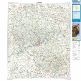
Wegenkaart - landkaart Mapa Provincial Cordoba | CNIG - Instituto Geográfico Nacional (9788441639232)
- ISBN / CODE: 9788441639232
- Editie: 01-12-2017
- Druk: 7
- Aantal blz.: 1
- Schaal: 1:200000
- Uitgever: CNIG - Instituto Geográfico Nacional
- Soort: Wegenkaart
- Serie: Mapa Provincial
- Taal: Spaans
- Hoogte: 25.0 cm
- Breedte: 10.0 cm
- Gewicht: 91.0 g
- Uitvoering: Papier
- Bindwijze: -
- Beoordeling: 5,0 ★★★★★ (1 review) Schrijf een review
-
€ 9,95
Op voorraad. Voor 17.00 uur op werkdagen besteld, binnen 1 tot 2 werkdagen in huis in Nederland Levertijd Belgie
Gratis verzending in Nederland vanaf €35,-
-
Overzicht Provincie Wegenkaarten Spanje
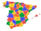
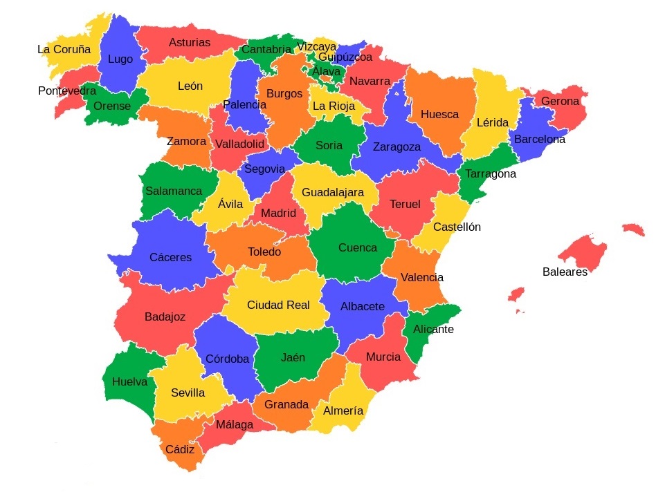
Producten op deze overzichtskaart:
Klik op een product om naar de pagina van dat product te gaan.
- Wegenkaart - landkaart Mapa Provincial Huesca | CNIG - Instituto Geográfico Nacional
- Wegenkaart - landkaart Mapa Provincial Lleida | CNIG - Instituto Geográfico Nacional
- Wegenkaart - landkaart Mapa Provincial Toledo | CNIG - Instituto Geográfico Nacional
- Wegenkaart - landkaart 31 Mapa Provincial Malaga | CNIG - Instituto Geográfico Nacional
- Wegenkaart - landkaart Mapa Provincial A Coruna | CNIG - Instituto Geográfico Nacional
- Wegenkaart - landkaart Mapa Provincial Alava Guipuzcoa Vizcaya | CNIG - Instituto Geográfico Nacional
- Wegenkaart - landkaart Mapa Provincial Albacete | CNIG - Instituto Geográfico Nacional
- Wegenkaart - landkaart Mapa Provincial Alicante | CNIG - Instituto Geográfico Nacional
- Wegenkaart - landkaart Mapa Provincial Almeria | CNIG - Instituto Geográfico Nacional
- Wegenkaart - landkaart Mapa Provincial Asturias | CNIG - Instituto Geográfico Nacional
- Wegenkaart - landkaart Mapa Provincial Avila | CNIG - Instituto Geográfico Nacional
- Wegenkaart - landkaart Mapa Provincial Badajoz | CNIG - Instituto Geográfico Nacional
- Wegenkaart - landkaart Mapa Provincial Barcelona | CNIG - Instituto Geográfico Nacional
- Wegenkaart - landkaart Mapa Provincial Burgos | CNIG - Instituto Geográfico Nacional
- Wegenkaart - landkaart Mapa Provincial Caceres | CNIG - Instituto Geográfico Nacional
- Wegenkaart - landkaart Mapa Provincial Cadiz | CNIG - Instituto Geográfico Nacional
- Wegenkaart - landkaart Mapa Provincial Cantabria | CNIG - Instituto Geográfico Nacional
- Wegenkaart - landkaart Mapa Provincial Castellon | CNIG - Instituto Geográfico Nacional
- Wegenkaart - landkaart Mapa Provincial Ciudad Real | CNIG - Instituto Geográfico Nacional
- Wegenkaart - landkaart Mapa Provincial Cordoba | CNIG - Instituto Geográfico Nacional
- Wegenkaart - landkaart Mapa Provincial Cuenca | CNIG - Instituto Geográfico Nacional
- Wegenkaart - landkaart Mapa Provincial Extremadura | CNIG - Instituto Geográfico Nacional
- Wegenkaart - landkaart Mapa Provincial Girona | CNIG - Instituto Geográfico Nacional
- Wegenkaart - landkaart Mapa Provincial Granada | CNIG - Instituto Geográfico Nacional
- Wegenkaart - landkaart Mapa Provincial Guadalajara | CNIG - Instituto Geográfico Nacional
- Wegenkaart - landkaart Mapa Provincial Huelva | CNIG - Instituto Geográfico Nacional
- Wegenkaart - landkaart Mapa Provincial Illes Balears - Balearen | CNIG - Instituto Geográfico Nacional
- Wegenkaart - landkaart Mapa Provincial La Rioja | CNIG - Instituto Geográfico Nacional
- Wegenkaart - landkaart Mapa Provincial Leon | CNIG - Instituto Geográfico Nacional
- Wegenkaart - landkaart Mapa Provincial Lugo | CNIG - Instituto Geográfico Nacional
- Wegenkaart - landkaart Mapa Provincial Madrid | CNIG - Instituto Geográfico Nacional
- Wegenkaart - landkaart Mapa Provincial Murcia | CNIG - Instituto Geográfico Nacional
- Wegenkaart - landkaart Mapa Provincial Navarra | CNIG - Instituto Geográfico Nacional
- Wegenkaart - landkaart Mapa Provincial Ourense | CNIG - Instituto Geográfico Nacional
- Wegenkaart - landkaart Mapa Provincial Palencia | CNIG - Instituto Geográfico Nacional
- Wegenkaart - landkaart Mapa Provincial Palencia | CNIG - Instituto Geográfico Nacional
- Wegenkaart - landkaart Mapa Provincial Pontevedra | CNIG - Instituto Geográfico Nacional
- Wegenkaart - landkaart Mapa Provincial Salamanca | CNIG - Instituto Geográfico Nacional
- Wegenkaart - landkaart Mapa Provincial Segovia | CNIG - Instituto Geográfico Nacional
- Wegenkaart - landkaart Mapa Provincial Sevilla | CNIG - Instituto Geográfico Nacional
- Wegenkaart - landkaart Mapa Provincial Soria | CNIG - Instituto Geográfico Nacional
- Wegenkaart - landkaart Mapa Provincial Tarragona | CNIG - Instituto Geográfico Nacional
- Wegenkaart - landkaart Mapa Provincial Teruel | CNIG - Instituto Geográfico Nacional
- Wegenkaart - landkaart Mapa Provincial Valencia | CNIG - Instituto Geográfico Nacional
- Wegenkaart - landkaart Mapa Provincial Valladolid | CNIG - Instituto Geográfico Nacional
- Wegenkaart - landkaart Mapa Provincial Zamora | CNIG - Instituto Geográfico Nacional
- Wegenkaart - landkaart Mapa Provincial Zaragoza | CNIG - Instituto Geográfico Nacional
Overzichtskaarten
Beschrijving
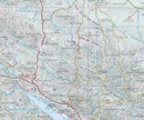
Deze kaart is zuiver gericht op de provincie als in de titel. Gebieden naast de kaart worden zonder kleur weergegeven. Ideale kaart als het gaat om het onderscheid in topografische details als hoogte, nationale parken, vegetatie en plaatsen. Met schaduwrelief wordt hoogte goed zichtbaar. Zeker geschikt voor fietsers, al heb je er soms wel veel nodig.
Nadeel is het feit dat deze kaarten niet altijd even goed up-to-date zijn. Het komt soms wel voor dat bepaalde wegen inmiddels veel groter zijn geworden dan ingetekend op de kaart. Maar dan gaat het vooral om de grotere wegen: voor kleinere details is het een prima kaart.
One of the titles in a series of contoured road maps from Spain's civilian survey organisation, each covering one administrative province, excellent in presenting the country’s topography and locations of its many national and natural parks. The maps have contours at 100-metre intervals enhanced by relief shading, plus spot heights. Additional colouring is used to indicate various types of vegetation. Boundaries of national/natural parks are highlighted. Road network includes minor local roads and tracks, and motorways distinguish between free and toll routes. Railways show high speed, double, and single track lines. Unless indicated to the contrary in the individual descriptions, the maps have UTM grid, plus latitude and longitude margin ticks at 15' intervals, and an index of place names on the reverse. The legend is in Spanish only. Unlike in the older versions of this series, on each title all the information continues outside the provincial boundary, but without the relief shading and vegetation colouring.
Reviews
Heel nauwkeurige kaart, alle dorpen staan erop. En alles staat duidelijk aangegeven.
★★★★★ door Arthur 17 oktober 2024 | Heeft dit artikel gekochtVond u dit een nuttige review? (login om te beoordelen)
Schrijf een review
Graag horen wij wat u van dit artikel vindt. Vindt u het goed, leuk, mooi, slecht, lelijk, onbruikbaar of erg handig: schrijf gerust alles op! Het is niet alleen leuk om te doen maar u informeert andere klanten er ook nog mee!

