Categorieën
- Nieuwe artikelen
- Boeken
-
Kaarten
- Camperkaarten
- Educatieve kaarten
- Fietskaarten
- Fietsknooppuntenkaarten
- Historische Kaarten
- Pelgrimsroutes (kaarten)
- Spoorwegenkaarten
- Stadsplattegronden
- Toerskikaarten
- Topografische kaarten
- Wandelatlassen
-
Wandelkaarten
- Afrika
- Azië
-
Europa
- Albanië
- Andorra
- Armenië
- België
- Bulgarije
- Cyprus
- Denemarken
- Duitsland
- Engeland
- Faroer
- Finland
- Frankrijk
- Georgië
-
Griekenland
- Vasteland Griekenland
- Thracië
- Macedonië (Griekenland)
- Epirus
- Thessalië
- Centraal-Griekenland
- Peloponnesos
- Griekse Eilanden
- Ionische Eilanden West
- ♦ Korfoe
- ♦ Kefalonia
- ♦ Lefkas
- ♦ Zakynthos
- Cycladen Zuid
- ♦ Santorini
- ♦ Naxos
- ♦ Paros
- Kreta
- Egeische Eilanden Noord-oost
- ♦ Limnos
- ♦ Samos
- ♦ Lesbos
- Sporaden (midden - oost)
- ♦ Skiathos
- Dodecanesos (zuid -oost)
- ♦ Karpathos
- ♦ Kos
- ♦ Patmos
- ♦ Rhodos - Rodos
- Saronische Eilanden - Golf van Egina
- IJsland
- Ierland
- Italië
- Kosovo
- Kroatië
- Letland
- Liechtenstein
- Luxemburg
- Malta
- Montenegro
- Nederland
- Noord-Ierland
- Noord-Macedonië
- Noorwegen
- Oekraïne
- Oostenrijk
- Polen
- Portugal
- Roemenië
- Rusland
- Schotland
- Servië
- Slovenië
- Slowakije
- Spanje
- Tsjechië
- Turkije
- Vaticaanstad
- Zweden
- Zwitserland
- Midden-Amerika
- Midden-Oosten
- Noord-Amerika
- Oceanië
- Zuid-Amerika
- Wandelknooppuntenkaarten
- Waterkaarten
- Wegenatlassen
- Wegenkaarten
- Wintersportkaarten
- Opruiming
- Puzzels
- Travel Gadgets
- Wandkaarten
- Wereldbollen
Veilig online betalen
Betaal veilig via uw eigen bankomgeving
- U bent hier:
- Home
- Europa
- Griekenland
- Vasteland Griekenland
- Kaarten
- Wandelkaarten
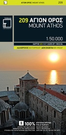
Wandelkaart - Wegenkaart - landkaart 209 Mount Athos | Terrain maps (9789609456999)
- ISBN / CODE: 9789609456999
- Editie: 01-04-2015
- Aantal blz.: 1
- Schaal: 1:50000
- Uitgever: Terrain maps
- Soort: Wandelkaart, Wegenkaart
- Taal: Engels
- Hoogte: 25.0 cm
- Breedte: 13.0 cm
- Gewicht: 77.0 g
- Uitvoering: Scheur- en watervast
- Schrijf als eerste een review
-
€ 12,50
Op voorraad. Binnen 2 - 3 werkdagen in huis in Belgie Levertijd Nederland Voor 17.00 uur op werkdagen besteld, binnen 1 tot 2 werkdagen in huis in Nederland Levertijd Belgie
Gratis verzending in Nederland vanaf €35,-
- Afbeeldingen
- Inkijkexemplaar
Beschrijving
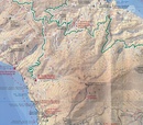
Gedetailleerde wegenkaart en wandelkaart met alle kleine wegen, wandelpaden, hoogtelijnen en toeristische informatie aangegeven. Alle tekst is tweetalig in Engels en Grieks en de waterproof kaart is geschikt voor gebruik met GPS.
- Κaryes town plan in 1:3.000 scale and Κaryes area map in 1:10.000 scale
- All monasteries, scetes, cells, seats and huts, marked with distinctive symbols and their names
- All walking trails, with measured distances
- A concise guide to the monasteries, and general information on Mt. Athos
- Printed on polyart
Reviews
Geen reviews gevonden voor dit product.
Schrijf een review
Graag horen wij wat u van dit artikel vindt. Vindt u het goed, leuk, mooi, slecht, lelijk, onbruikbaar of erg handig: schrijf gerust alles op! Het is niet alleen leuk om te doen maar u informeert andere klanten er ook nog mee!
Ook interessant voor europa/griekenland/overige-streken-vasteland
-

Wegenkaart - landkaart 54 Centraal G
€ 10,25Wegenkaarten Vasteland Griekenland -

Wandelgids Zagoria-Trek Griekenland
€ 14,90Wandelgidsen Vasteland Griekenland -

Reisgids Nord- und Mittel Griechenla
€ 32,50Reisgidsen Vasteland Griekenland -

Wandelkaart 4.1 Agrafa- Lake Plasti
€ 11,95Wandelkaarten Vasteland Griekenland -

Wegenatlas Central Greece - Centraal
€ 26,95Wegenatlassen Vasteland Griekenland


