Categorieën
- Nieuwe artikelen
-
Boeken
- Aanwijswoordenboeken
- Accommodatiegidsen
- Atlassen
- Bed and Breakfast Gidsen
- Bergsporthandboeken
- Campergidsen
- Camperhandboeken
- Campinggidsen
- Duikgidsen
- Fietsatlassen
- Fietsgidsen
- Fotoboeken
- Historische Atlassen
- Kanogidsen
- Kinderatlassen
- Kinderreisgidsen
- Kleurboeken
- Klimgids - Klettersteiggidsen
- Klimgids - Klimtopo
- Kookboeken
- Mountainbikegidsen
- Natuurgidsen
- Pelgrimsroutes
- Reisboeken
- Reisdagboeken
- Reisfotografiegidsen
- Reisgidsen
- Reishandboeken
- Reisinspiratieboeken
- Reisverhalen
- Sneeuwschoenwandelgidsen
- Survivalgidsen
- Tourskigidsen
- Treinreisgidsen
- Vaargidsen
- Vogelgidsen
-
Wandelgidsen
- Afrika
- Azië
-
Europa
- Albanië
- Andorra
- Armenië
- België
- Bosnië - Hercegovina
- Bulgarije
- Cyprus
- Denemarken
- Duitsland
-
Engeland
- Noord Engeland
- North East England
- ♦ Northumberland National Park
- Yorkshire and the Humber
- ♦ Yorkshire Dales Nationaal Park
- ♦ North York Moors Nationaal Park
- ■ York
- North West England
- ♦ Cumbria
- ♦ Isle of Man
- ♦ Lake District Nationaal Park
- ♦ North Pennines AONB
- ■ Liverpool
- ■ Manchester
- 🥾 Hadrian's Wall Path
- East Midlands
- West Midlands
- ♦ Peak District Nationaal Park
- ■ Birmingham
- Wales
- Swansea and the Gower
- ♦ Pembrokeshire Coast National Park
- ♦ Snowdonia Nationaal Park
- ♦ Brecon Beacons Nationaal Park
- East of England - East Anglia
- ♦ The Broads National Park
- South West England
- Cornwall
- Devon
- Dorset
- ■ Bath
- ♦ Cotswolds AONB
- ♦ Devon - Cornwall
- 🥾 South West Coast Path
- ♦ New Forrest National Park
- ♦ Exmoor National Park
- ♦ Dartmoor National Park
- ■ Bristol
- South East England
- ♦ Kent
- ♦ South Downs Nationaal Park
- ♦ Isle of Wight
- ■ Londen
- ■ Oxford
- Kanaaleilanden
- ♦ Guernsey
- ♦ Jersey
- Meer steden
- Estland
- Faroer
- Finland
- Frankrijk
- Georgië
- Griekenland
- Groenland
- Hongarije
- IJsland
- Ierland
- Italië
- Kosovo
- Kroatië
- Letland
- Liechtenstein
- Litouwen
- Luxemburg
- Malta
- Montenegro
- Nederland
- Noord-Ierland
- Noord-Macedonië
- Noorwegen
- Oostenrijk
- Polen
- Portugal
- Roemenië
- Scandinavië
- Schotland
- Servië
- Slovenië
- Slowakije
- Spanje
- Tsjechië
- Turkije
- Zweden
- Zwitserland
- Midden-Amerika
- Midden-Oosten
- Noord-Amerika
- Oceanië
- Wereld
- Zuid-Amerika
- Watersport handboeken
- Werken en wonen in buitenland
- Woordenboeken & Taalgidsen
- Kaarten
- Opruiming
- Puzzels
- Travel Gadgets
- Wandkaarten
- Wereldbollen
Veilig online betalen
Betaal veilig via uw eigen bankomgeving
- U bent hier:
- Home
- Europa
- Engeland
- Yorkshire and the Humber
- Boeken
- Wandelgidsen
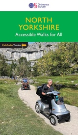
Wandelgids 093 Pathfinder Guides North Yorkshire Accessible walks for all | Ordnance Survey (9780319092859)
- ISBN / CODE: 9780319092859
- Editie: 01-10-2024
- Aantal blz.: 94
- Uitgever: Ordnance Survey
- Soort: Wandelgids
- Serie: Pathfinder Guides
- Taal: Engels
- Hoogte: 23.0 cm
- Breedte: 13.0 cm
- Gewicht: 207.0 g
- Bindwijze: Paperback
- Uitvoering: -
- Schrijf als eerste een review
-
€ 18,95
Leverbaar in 3 - 5 werkdagen in huis in Belgie Levertijd Nederland Leverbaar in 3 - 5 werkdagen in huis in Nederland Levertijd Belgie
Gratis verzending in Nederland vanaf €35,-
- Inkijkexemplaar
Beschrijving
Van de uitgever
This guide comprises 33 beautiful walks, ranging in distance from 0.5 to 8 miles, across North Yorkshire, with ten routes in the Yorkshire Dales National Park, eleven in the North York Moors National Park, North Sea coast routes at Whitby, Robin Hood’s Bay and Bempton, and routes handily placed near the Richmond, Ripon, Thirsk and York.Walks are sequenced in the book from shortest to longest, while each all-abilities route is graded for wheelchairs according to one of three accessibility ratings: for all, for many and for some. By design, these routes are all pushchair friendly and make delightful, reasonably gentle walks for everyone to enjoy.
Route descriptions are presented with GPS waypoints, large-scale OS Explorer mapping and feature of interest information, with notes on parking and accessibility. You can enjoy the calming, sylvan beauty of peaceful Nettledale, roam the extensive parkland at Castle Howard, and explore the fascinating geological outcrops at Brimham Rocks.
OS Pathfinder Guides: Outstanding Circular Walks
The definitive pocket book guide to Great Britain’s great outdoors
38 fully accessible walks for all Walks ranging from ¾ to 8 miles vast majority less than 3 miles with almost half linear
Photos showing typical path conditions for routes with tricky points
Packed with essential information per walk: Start / finish position, travel information on how to get there, parking, toilets and refreshments stops, distance and time, terrain
Includes OS Explorer 1:25 000 scale map extracts for every route (4cm to 1km or 2½ inches to one mile)
Discover GPS waypoints, parking information and detailed route descriptions for foolproof navigation
Enhances your walk with information on rare wildlife, natural habitats and points of historical interest
Reviews
Geen reviews gevonden voor dit product.
Schrijf een review
Graag horen wij wat u van dit artikel vindt. Vindt u het goed, leuk, mooi, slecht, lelijk, onbruikbaar of erg handig: schrijf gerust alles op! Het is niet alleen leuk om te doen maar u informeert andere klanten er ook nog mee!
Ook interessant voor europa/engeland/yorkshire-and-the-humber
-

Wegenkaart - landkaart Visitors map
€ 11,50Wegenkaarten Yorkshire and the Humber -

Stadsplattegrond Pocket Street Map S
€ 7,95Stadsplattegronden Yorkshire and the Humber -

Wandelgids 093 Pathfinder Guides Nor
€ 18,95Wandelgidsen Yorkshire and the Humber -

Reisgids Pocket Rough Guide York | R
€ 14,95Reisgidsen Yorkshire and the Humber -

Reisverhaal Walking the Wharfe | Joh
€ 14,95Reisverhalen Yorkshire and the Humber


